
 Often times property owners in the course of their lives are confronted with a situation where they are told, or feel that they need a “survey” this term means different things to different people and there are several types of surveys. Most fall under the category of what we consider a “boundary retracement surveys”. Generally most people envision stakes in the ground delineating a lot line. Like an iceberg, stakes in the ground is really just the tip, or “jimmies” on top of an ice cream cone. The vast majority of work relies on first researching the public record to determine what you own, researching your abutters to determine what they own. Researching how the property was originally conveyed in other words by subdivision plat or sequentially as some larger piece of land was cut up and sold. The surveyor must then try and find monuments in the field that enjoy a history in the chain of title. Often times these monuments can be hundreds or even thousands of feet away from the locus property often times it is necessary to enter the properties of adjacent land owners to locate these monuments. After the initial research, field investigation and measurements this information is brought back to the office and analyzed to determine the reliability of various monuments and make a determination is made as to how best retrace your lot lines. Often times during this process we will locate structures that are affixed to the property, evidence of occupation, fences, walls and limits of clearing etc. We can then present this data to the client in several forms:
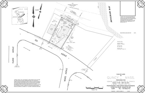
A certified plot plan – This document is used to “certify” offset dimensions from existing and proposed structures, etc. to lot lines. This is calculated in the computer and rendered and does not necessarilyhave to involve actually marking the line on the ground, however it will show the results of the instrument survey and the lines can be marked at a later date if necessary.
Lot line stake out – Before erecting fences, landscaping etc. stakes in the allow you to avoid placing these expensive improvements off your property. This involves the same process as stated earlier with the final step of going back to the site and marking and monumenting of the lot lines and corners.
It is important to note that the only person, by law that can determine the location of a lot line and or an offset distance from an entity to a lot line is a Registered Professional Land Surveyor. Not an engineer, not a real estate agent, not a contractor, not your father’s brother.
So what happens if you or your abutter doesn’t agree with a survey? First it is important to mention that any line we mark on the ground or plan that we draw is prepared with the intention that we will be willing to defend it, all the way to court, forever. At the first notice of a disagreement, with the permission of our client we will then attempt to explain how we came up with our determination, we re- review our work to insure no mistakes were made. Often times this remedies the situation. If it does not the disagreeing party must then hire their own Professional Land surveyor to do an independent survey. If those surveys do not agree, the two professionals try to resolve the issue. If they are unable to resolve the issue it may have to go to court where both sides are presented and a judge and or jury can decide.
Common sense: Unless you are in a public street, park or other defined “public area” or your own land you are on private property. Many people fail to recognize this and feel that they have the right to ride all-terrain vehicles, horses, walk dogs, cut trees/brush and dump yard waste wherever no one is occupying or defending. It’s ok to be territorial! Know your boundaries! I recommend that everyone upon purchasing a piece of land have their boundaries marked, know the location of those monuments and defend yourself from potential encroachment issues before they occur.